Update, Thursday at 2:15 p.m.: Flagler County posted photos to its Facebook page of “devastation” on the coastal Florida State Road A1A after Tropical Storm Nicole.
https://www.facebook.com/plugins/post.php?href=https%3A%2F%2Fwww.facebook.com%2FFlaglerCountyGovernment%2Fposts%2F449954720584129&show_text=true&width=500
Read more from the Florida Storms team about the state’s worst affected areas.
Thursday at 1:45 p.m.:
WILBUR-BY-THE-SEA, Fla. (AP) — Tropical Storm Nicole sent multiple homes toppling into the Atlantic Ocean Thursday and threatened a row of high rise condominiums in places where Hurricane Ian washed away the beach and destroyed seawalls only weeks ago.
“Multiple coastal homes in Wilbur-by-the-Sea have collapsed and several other properties are at imminent risk,” Volusia County Sheriff Mike Chitwood said in a social media message. He said most bridges to the beachside properties have been closed to all but essential personnel and a curfew was put into effect.
Wilbur-by-the-Sea is an unincorporated community on a barrier island with only beachfront homes. Next door in Daytona Beach Shores, a strip of high-rise condominiums were evacuated ahead of Nicole’s landfall, and while they remained standing after the storm, their future depends on safety reviews.
The homeowners association at the Marbella condominiums had just spent $240,000 to temporarily rebuild the seawall Ian destroyed in September, said Connie Hale Gellner, whose family owns a unit there. Live video from the building’s cameras showed Nicole’s storm surge taking it all way.


Thursday at 12:50 p.m.: The Putnam County town of Welaka, located south of Palatka on the St. Johns River, is seeing heavy flooding as high tide approaches later this afternoon.
Thursday at 11:33 a.m.: A livestream of the Flagler Beach Pier late Thursday morning showed storm surge pushing well past the normal high tide lines.
Thursday at 10:37 a.m.: Florida Gov. Ron DeSantis delivered an update just before 10:30 a.m. and said more than 300,000 customers are now without power statewide.
Thursday at 9:15 a.m.: The strongest winds in north central Florida are ahead in the next few hours. Alachua County just made this announcement: “Thankfully we had a fairly uneventful evening. We are expecting the strongest TS Nicole winds to happen today between 10 a.m. and 2 p.m. with gusts of up to 40 to 60 miles per hour. Rainfall is expected to be approximately 2 inches. Currently, the center of the storm is approaching Orlando.”
Update, Thursday at 9:15 a.m.: The strongest winds in north central Florida are ahead in the next few hours. Alachua County just made this announcement: “Thankfully we had a fairly uneventful evening. We are expecting the strongest TS Nicole winds to happen today between 10 a.m. and 2 p.m. with gusts of up to 40 to 60 miles per hour. Rainfall is expected to be approximately 2 inches. Currently, the center of the storm is approaching Orlando.”
Thursday at 9:05 a.m.: Power outages across Florida are nearing 250,000, with a small handful of those in the north central Florida area.
Clay Electric reports about 14,000 outages in its service area, with the most so far in Clay, Lake and Putnam counties.
Thursday at 7:55 a.m.:
Tropical Storm Nicole made landfall as a hurricane along the east coast of Florida early Thursday and is such a sprawling storm that it covered nearly the entire state and reached into Georgia, the Carolinas and Alabama. A large area of the storm-weary peninsula was being hit with strong winds and heavy rain, with damaging storm surge in a few coastal areas.
The rare November hurricane prompted officials to shut down airports and theme parks and order evacuations in areas that included former President Donald Trump’s Mar-a-Lago club. Authorities warned that Nicole’s storm surge could further erode many beaches hit by Hurricane Ian in September.
Tropical storm force winds extended as far as 450 miles (720 kilometers) from the center in some directions as Nicole turned northward over central Florida Thursday morning. It could briefly emerge over the northeastern corner of the Gulf of Mexico Thursday afternoon before moving over the Florida Panhandle and Georgia, forecasters said.
Robbie Berg, a hurricane specialist at the National Hurricane Center in Miami advised people to understand that hazards from Tropical Storm Nicole “will exist across the state of Florida today.”
The storm left south Florida sunny and calm as it moved north, could dump as much as 6 inches (15 centimeters) of rain over Blue Ridge Mountains by Friday, forecasters said.
Nicole made landfall as a Category 1 hurricane around Vero Beach at about 3 a.m. Thursday before its maximum sustained winds dropped to 60 mph (100 kph), the Miami-based center said. The storm was centered about 30 miles (50 kilometers) southeast of Orlando. It was moving west-northwest near 14 mph (22 kph).
Officials in Daytona Beach Shores deemed unsafe at least a half dozen, multi-story, coastal residential buildings already damaged by Hurricane Ian and now threatened by Nicole. At some locations, authorities went door-to-door telling people to grab their possessions and leave.
A few tornadoes were possible through early Thursday across east-central to northeast Florida, the forecasters said. Flash and urban flooding will be possible, along with renewed river rises on the St. Johns River, across the Florida Peninsula on Thursday. Heavy rainfall will spread northward across portions of the southeast, eastern Ohio Valley, Mid-Atlantic, and New England through Saturday.
Large swells generated by Nicole will affect the northwestern Bahamas, the east coast of Florida, and much of the southeastern United States coast over the next few days. The storm was expected to weaken into a tropical depression over Georgia on Thursday night or early Friday.
Nicole became a hurricane Wednesday evening as it slammed into Grand Bahama Island, having made landfall just hours earlier on Great Abaco island as a tropical storm. It was the first storm to hit the Bahamas since Hurricane Dorian, a Category 5 storm that devastated the archipelago in 2019.
For storm-weary Floridians, it is only the third November hurricane to hit their shores since recordkeeping began in 1853. The previous ones were the 1935 Yankee Hurricane and Hurricane Kate in 1985.
Mar-a-Lago, Trump’s club and home, was in one of the evacuation zones, built about a quarter-mile inland from the ocean. The main buildings sit on a small rise that is about 15 feet (4.6 meters) above sea level and the property has survived numerous stronger hurricanes since it was built nearly a century ago. The resort’s security office hung up Wednesday when an Associated Press reporter asked whether the club was being evacuated, and there was no sign of evacuation by Wednesday afternoon.
There is no penalty for ignoring an evacuation order, but rescue crews will not respond if it puts their members at risk.
Disney World and Universal Orlando Resort announced they likely would not open as scheduled Thursday.
At a news conference Wednesday in Tallahassee, Gov. Ron DeSantis said that winds were the biggest concern and significant power outages could occur, but that 16,000 linemen were on standby to restore power as well as 600 guardsmen and seven search and rescue teams.
“It will affect huge parts of the state of Florida all day,” DeSantis said of the storm’s expected landing.
Almost two dozen school districts were closing schools for the storm and 15 shelters had opened along Florida’s east coast, the governor said.
Forty-five of Florida’s 67 counties were under a state of emergency declaration.
Warnings and watches were issued for many parts of Florida, including the southwestern Gulf coastline that was devastated by Hurricane Ian, which struck as a Category 4 storm. The storm destroyed homes and damaged crops, including orange groves, across the state — damage that many are still dealing with. Ian brought storm surge of up to 13 feet (4 meters), causing widespread destruction.


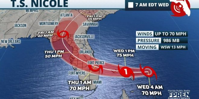
As of 7 a.m. Wednesday, Tropical Storm Nicole is located east of the Bahamas moving westward at 13 mph. Tropical Storm force winds are expected to increase along the Florida Atlantic coast this morning and will continue spread across the Peninsula this afternoon and evening. Nicole is forecast to make landfall late this evening in SE Florida as a hurricane with winds up to 75 mph. Along with increasing winds through this evening, dangerous storm surge up to 5 feet is possible into the overnight hours.
Hurricane Warnings are still posted along the east-central Florida coast as well as Storm Surge Warnings for most of the coastline. Residents are highly encouraged to finish preparations as soon as possible, and stay sheltered during the storm.

Nicole will likely track across the central Peninsula Thursday morning then possibly move into the NE Gulf of Mexico Thursday afternoon with sustained winds up to 50 mph. Most of the Florida Peninsula is under Tropical Storm Warnings and will experience several inches of rain, local flooding, possible power outages, and isolated tornadoes during the day.

By Thursday evening, Nicole is forecast to move quickly through the Panhandle closer to Tallahassee with sustained winds up to 40 mph. Flooding rains are possible through the central and eastern Panhandle along with storm surge inundations up to 3 feet along the Big Bend Coast.
Nicole will be closely monitored and continuous updates will be provided today and all day Thursday until the storm and impacts finally move out of Florida tomorrow night. Unnecessary travel is highly discouraged during this time.
Florida Gator Athletics
All home Gator athletic events scheduled for Friday, Saturday and Sunday will be held as planned. The University Athletic Association will continue to work with UF, local and state officials to monitor Tropical Storm Nicole.